FEMA Flood Maps: Better Planning and Analysis Needed to Address Current and Future Flood Hazards
Fast Facts
The Federal Emergency Management Agency maps flood hazard areas to help guide the National Flood Insurance Program and the flood mitigation efforts of property owners, community planners, insurers, and others. (The insurance program is on our High Risk List.)
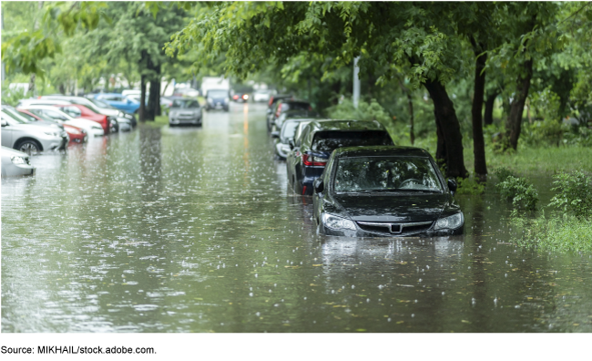
The FEMA flood hazard maps we examined didn't reflect the best available climate science or include information on current flood hazards (e.g., heavy rainfall that overwhelms existing storm drainage systems). FEMA's flood mapping program may take years to address these issues and has been operating under an out-of-date plan. Our recommendations address these issues and more.
Highlights
What GAO Found
The Federal Emergency Management Agency's (FEMA) Risk Mapping, Assessment, and Planning (Risk MAP) program has increased its development of flood maps and other flood risk products, but faces challenges ensuring they comprehensively reflect current and future flood hazards. For example, its flood risk products do not reflect hazards such as heavy rainfall and the best available climate science. These products include maps—known as Flood Insurance Rate Maps—and nonregulatory flood risk products such as estimates of flood damage in an area. FEMA's Risk MAP program is addressing some of these challenges, but many may require years to address. However, Risk MAP has been operating under an out-of-date plan that does not reflect new goals, objectives, activities, performance measures, and associated timeframes. Updating its program plan to include these elements could help FEMA effectively manage and coordinate its efforts to incorporate current and future flood hazards in a timely way.
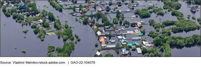
Example of River Flooding
FEMA does not periodically assess the usefulness of its nonregulatory flood risk products, which are intended to help communities increase their resilience to floods. According to FEMA, it has invested millions of dollars in developing Risk MAP nonregulatory products; however, the agency has not assessed the usefulness of these products in increasing community resilience since 2016. Establishing mechanisms for periodically assessing the usefulness of its nonregulatory products could help FEMA ensure it is investing in products that address community need and have a meaningful impact on enhancing flood resilience.
FEMA prioritizes mapping projects with input from all levels of government and FEMA regional offices, but could better use available data to inform its mapping efforts. FEMA's decision-making process has emphasized directing resources to areas with greatest flood risks. Additionally, in 2020, FEMA established a strategic priority for considering socially-vulnerable populations as part of disaster resilience. According to GAO's statistical analyses of data from the Risk MAP program and FEMA's publicly available disaster risk assessment tools, FEMA's mapping investments for fiscal years 2012 to 2020 were greater where flood risks were higher, but were lower for areas of higher socially-vulnerable populations. By considering ways to leverage available data into its annual process for prioritizing its flood mapping investments, FEMA could enhance its ability to make well-informed decisions that meet agency and federal priorities and disaster resilience goals.
Why GAO Did This Study
FEMA is responsible for producing and updating Flood Insurance Rate Maps and nonregulatory products to show areas of greatest flood hazards and help guide floodplain management actions under the National Flood Insurance Program. While FEMA has mapped millions of miles of the nation's streams and coastlines, questions have been raised about whether its flood risk products provide a comprehensive picture of flood risk.
The Additional Supplemental Appropriations for Disaster Relief Act of 2019 required GAO to review issues related to 2018 disasters. As part of this body of work, this report addresses (1) the extent FEMA has developed Flood Insurance Rate Maps and nonregulatory products that reflect current and future flood hazards, (2) the extent FEMA has assessed its efforts to enhance flood resilience, and (3) how FEMA prioritizes its mapping resources to create and update Flood Insurance Rate Maps. GAO reviewed agency documents and strategic plans; analyzed FEMA data; and interviewed FEMA, selected states and localities, and flood mapping experts.
Recommendations
GAO recommends that FEMA (1) update its Risk MAP program plan to identify goals, time frames, and other elements related to its efforts to reflect current and future flood hazards; (2) develop mechanisms to assess the usefulness of its nonregulatory flood risk products; and (3) consider ways to leverage its flood risk data to help prioritize its mapping investment decisions. The Department of Homeland Security concurred with our recommendations.
Recommendations for Executive Action
| Agency Affected Sort descending | Recommendation | Status |
|---|---|---|
| Federal Emergency Management Agency | The Administrator of FEMA should update its multiyear plan for the Risk MAP program to identify program goals, objectives, activities, performance measures, and time frames for its various efforts to address challenges in reflecting current and future flood hazards and to transition to a future program. (Recommendation 1) |
Closed – Implemented
In October 2021, we found that the Federal Emergency Management Agency's (FEMA) Risk Mapping, Assessment, and Planning (Risk MAP) program has increased its development of flood maps and other flood risk products. However, we found that FEMA faces challenges ensuring they comprehensively reflect current and future flood hazards. Further, FEMA has been operating under an out-of-date plan that does not reflect new goals, objectives, activities, performance measures, and associated timeframes. We recommended FEMA update its multiyear flood mapping plan to identify program goals, objectives, activities, performance measures, and time frames for its various efforts to address challenges in reflecting current and future flood hazards and to transition to a future program. In March 2023, FEMA released its Risk MAP Multi-Year Plan for 2023 through 2027. The Plan states it was developed to respond to our October 2021 report. The Plan identifies 5 goals and 18 objectives and outlines how Risk MAP will proceed during the 5-year period from the Present Phase, through an Interim Phase where FEMA addresses existing gaps in flood resilience processes, to a Future Phase with the goal to more effectively reduce disaster suffering. GAO has reviewed the Plan and communicated with FEMA officials. We concluded that FEMA's updated multiyear plan clearly identifies its goals, objectives, activities, performance measures, and time frames for each of its ongoing efforts in order to ensure they are managed and coordinated effectively and carried out in a timely manner. As a result, this recommendation is closed as implemented.
|
| Federal Emergency Management Agency | The Administrator of FEMA should establish mechanisms for periodically assessing the usefulness of its Risk MAP nonregulatory products for communities in increasing their flood resilience. Such mechanisms could include tracking increases in building standards among those communities that use nonregulatory products, or conducting periodic loss avoidance studies. (Recommendation 2) |
Closed – Implemented
In October 2021, we found that FEMA does not periodically assess the usefulness of its nonregulatory flood risk products, which are intended to help communities increase their resilience to floods. According to FEMA, it has invested millions of dollars in developing Risk MAP nonregulatory products; however, the agency has not assessed the usefulness of these products in increasing community resilience since 2016. We recommended FEMA should establish mechanisms for periodically assessing the usefulness of its nonregulatory products. Such mechanisms could help FEMA ensure it is investing in products that address community need and have a meaningful impact on enhancing flood resilience. In response, FEMA formally launched a survey in October 2023 that allows for communities that have received FEMA's Risk Map nonregulatory products over the past 6 years to provide feedback on the usefulness of those products for increasing community flood resilience. The objectives of FEMA's survey were to assess community needs, understand the extent that nonregulatory products are being used to enhance flood risk mitigation and reduce future flood losses, and identify any gaps with existing FEMA products and the need for new products. FEMA's survey was sent to over 8,000 communities during October to November 2023. GAO has reviewed these documents and determined that FEMA's actions will help the agency ensure it is investing in products that address community need and have a meaningful impact on enhancing flood resilience. As a result, this recommendation is closed as implemented.
|
| Federal Emergency Management Agency | The Administrator of FEMA should consider ways to leverage and integrate available flood risk data, such as through statistical analyses, into its annual process for prioritizing flood mapping investments. Such available data sources include its Risk MAP's inventory of FIRM mapping projects and FEMA's national disaster risk assessment tools. (Recommendation 3) |
Closed – Implemented
In October 2021, our statistical analyses showed that the Federal Emergency Management Agency (FEMA's) flood mapping investments were greater where flood risks were higher, but lower for areas of higher socially-vulnerable populations. Therefore, we recommended FEMA consider ways to leverage and integrate available flood risk data into its annual process for prioritizing flood mapping investments to enhance its ability to make targeted, well-informed decisions that meet agency and federal priorities and disaster resilience goals. In response, FEMA developed an additional project management tool-RiskMAP Mapping Needs Explorer-as a resource for data evaluation in project selection. Additionally, FEMA has updated its Guidance and Standards which requires that all new studies document the data elements used to select a given area as a priority for study. FEMA officials told us that they have briefed FEMA regional offices on these updates to their project selection processes. GAO has reviewed these documents and determined that FEMA's added project selection tools and guidance leverages data such as levels of social vulnerability-the social, economic, demographic, and housing characteristics of a community, as well as other risk, mitigation, and climate data. As a result, this recommendation is closed as implemented.
|