How Can FEMA and Flood Insurance Keep Up with Rising Flood Risks?
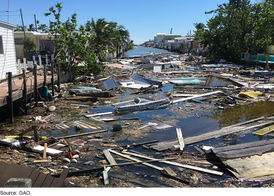
This year may go on record as one of the most active and costly years for natural disasters. As of Oct. 8, there have been 18 weather-related disaster events, each with losses exceeding $1 billion, according to the National Centers for Environmental Information. In fact, flooding is the costliest natural disaster annually in the United States.
Weather events have long been a threat to homeowners, but they are a threat to taxpayers too. Congress created the National Flood Insurance Program (NFIP) in 1968 to protect homeowners from flood losses, but also to reduce the federal government’s (and thus taxpayers’) exposure. However, the growing magnitude of major flood events, combined with attempts to keep homeowners’ insurance rates affordable, threatens the program’s solvency.
Today’s WatchBlog post explores our recent work on how the Federal Emergency Management Agency (FEMA) maps properties required to have flood insurance, and how communities plan for floodplain management.
Image
FEMA’s role in the development of floodplain maps
Some homeowners that live in certain areas that are at high risk of flooding are required by federal law to purchase flood insurance. FEMA is responsible for drawing the maps that determine which homeowners must purchase flood insurance.
In July 2021, we reported that FEMA’s floodplain maps do not fully capture flood risk. FEMA’s floodplain maps do not reflect risks from all types of flood events or how flood risk will likely change in the future. For example, some properties that may experience challenges posed by climate change are not required to purchase flood insurance.
We also found that some maps are dated and, as a result, do not fully capture flood risk. For example, about 15% of FEMA’s maps are over 15 years old, which means homeowners may not be aware of their current risk, and thus may not be insured against it.
Our October 2021 report also found weaknesses in FEMA’s planning and analysis of current and future flood hazards when developing maps. FEMA’s Risk Mapping, Assessment, and Planning (Risk MAP) program that delivers flood hazard information to the public could improve its planning and performance measurement of flood mapping efforts to ensure floodplain maps reflect hazards such as heavy rainfall and the best available climate science. For example, FEMA’s Risk MAP program had been operating under a plan developed in 2009 that does not reflect new goals, objectives, activities, performance measures, and associated timeframes.
How can climate change and other future conditions be incorporated into FEMA’s maps?
More frequent and intense flooding from climate-related weather events directly threatens the nation in the future. FEMA’s ongoing efforts to develop more comprehensive and up-to-date flood risk information for its mapping program could help determine who should be required to purchase flood insurance. Our July 2021 report made two recommendations to FEMA and also suggested that Congress require FEMA to act. Moreover, our October 2021 report made three recommendations to FEMA, including having an updated mapping program plan to help ensure that FEMA effectively incorporates current and future flood hazards in a timely way into its maps.
We added NFIP to our High Risk List in 2006 and added the federal government’s fiscal exposure to climate change in 2013. Want to learn more about our recent work on the National Flood Insurance Program? Learn more here.
Comments on GAO’s WatchBlog? Contact blog@gao.gov.
GAO Contacts


Related Products
GAO's mission is to provide Congress with fact-based, nonpartisan information that can help improve federal government performance and ensure accountability for the benefit of the American people. GAO launched its WatchBlog in January, 2014, as part of its continuing effort to reach its audiences—Congress and the American people—where they are currently looking for information.
The blog format allows GAO to provide a little more context about its work than it can offer on its other social media platforms. Posts will tie GAO work to current events and the news; show how GAO’s work is affecting agencies or legislation; highlight reports, testimonies, and issue areas where GAO does work; and provide information about GAO itself, among other things.
Please send any feedback on GAO's WatchBlog to blog@gao.gov.