Overseas Real Property: State's Initial Assessment of Natural Hazard Risks Faced By its Posts
Fast Facts
In 2020, the State Department created a Climate Security and Resilience program. The program assesses the risk natural hazards pose to each of its 294 locations around the world.
State selected 8 natural hazards for its assessment: coastal flooding, riverine flooding, tsunamis, earthquakes, water stress (i.e., lack of fresh water to meet demand), extreme heat, extreme wind, and landslides. State's assessment of the risks these hazards pose can help it develop and prioritize ways to adapt.
Its first risk review, as of May 2022, suggests half of facilities at highest risk are in East Asia and the Pacific, as shown by our interactive map.
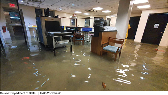
Flooding at the U.S. Embassy in Manila, Philippines in August 2022
Highlights
What GAO Found
The U.S. Department of State’s Climate Adaptation and Resilience Plan, issued in October 2021, outlines priority actions to make State’s personnel, facilities, and operations resilient to future natural hazards. One of these actions is to screen State facilities for hazards to identify those that are most at-risk and require further assessment and intervention. As of May 2022, State completed an initial assessment of its 294 posts around the world in terms of the potential risk posed by eight natural hazards—extreme heat, extreme wind, water stress, riverine flooding, coastal flooding, earthquake, landslide, and tsunami. GAO developed an interactive map based on State’s data showing total risk and the eight natural hazard-specific risks for every post; the map is accessible here. Of the 32 posts in the top risk percentile, half (16) of the posts are in the East Asia and Pacific region. These posts in the East Asia and Pacific region are at high risk across more types of natural hazards relative to other regions. State’s data suggests that the U.S. embassy in Manila, Philippines, is the post at highest risk of being affected by natural hazards compared to all other posts.
State considered natural hazard exposure, potential severity of damage based on post-specific information, and vulnerability factors (post-specific and country-wide) to determine risk. Based on the three components of this model, the presence of a high hazard exposure does not necessarily mean a post is at high risk relative to other posts, because post-specific conditions may indicate low impact or susceptibility to that hazard. For example, if a post is located near a coast but comprises newer facilities with ample access to critical services, State would score the post as lower overall risk relative to other posts, even if the city could be at high exposure to coastal flooding. State officials told us that this risk assessment is iterative in nature and that they intend to continue to refine and update the assessment.
Why GAO Did This Study
Climate change and increasingly frequent and extreme weather events have caused a surge in global natural disasters over the past 50 years, according to the World Meteorological Organization. State has concluded that natural hazards may pose a threat to the safety and security of its overseas diplomatic assets, consisting of more than 90,000 personnel and properties valued at approximately $70 billion in over 290 locations. According to State, the increasing frequency and severity of natural hazards heightens the risk of disruption to ongoing operations at its overseas locations (posts) from damage or degradation to real property assets—including office buildings, support facilities, and staff residences—that comprise these posts.
GAO was asked to review State’s efforts to identify which of its posts are at greatest risk of disruption from the effects of natural hazards. This report describes (1) State’s assessment of the risks of disruption from natural hazards at its posts, and (2) the methodology State used to determine these risks. To conduct this work, GAO reviewed, and discussed with agency officials, data and methodology documents provided by State on determining risks from the natural hazards faced by posts. GAO will continue to monitor State’s efforts to identify and address natural hazard risks to its overseas posts.
For more information, contact Jason Bair at (202) 512-6681 or bairj@gao.gov, or Catina B. Latham at (202) 512-2834 or lathamc@gao.gov.