Science & Tech Spotlight: Air Quality Sensors
Fast Facts
The U.S. has networks of pollution monitoring sites that use air quality sensors. But the networks have shortcomings such as trouble detecting localized pollution.
Technological improvements have led to smaller, more affordable air quality sensors and better satellite-based sensors. These can help close gaps in pollution monitoring and research. For example, through more dense and widespread monitoring, these sensors may help pinpoint air pollution sources and hot spots and improve understanding of community exposure.
But these sensors vary in performance, can be hard to interpret, and may not monitor key pollutants such as some air toxics.
Types of Air Quality Sensors
Highlights
Why This Matters
Air quality sensors are essential to measuring and studying pollutants that can harm public health and the environment. Technological improvements have led to smaller, more affordable sensors as well as satellite-based sensors with new capabilities. However, ensuring the quality and appropriate interpretation of sensor data can be challenging.
The Technology
What is it? Air quality sensors monitor gases, such as ozone, and particulate matter, which can harm human health and the environment. Federal, state, and local agencies jointly manage networks of stationary air quality monitors that make use of sensors. These monitors are expensive and require supporting infrastructure. Officials use the resulting data to decide how to address pollution or for air quality alerts, including alerts during wildfires or on days with unhealthy ozone levels. However, these networks can miss pollution at smaller scales and in rural areas. They generally do not measure air toxics—more localized pollutants that may cause cancer and chronic health effects—such as ethylene oxide and toxic metals. Two advances in sensor technologies may help close these gaps.
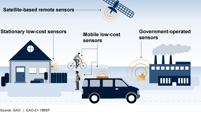
First, newer low-cost sensors can now be deployed virtually anywhere, including on fences, cars, drones, and clothing (see fig. 1). Researchers, individuals, community groups, and private companies have started to deploy these more affordable sensors to improve their understanding of a variety of environmental and public health concerns.
Second, federal agencies have for decades operated satellites with sensors that monitor air quality to understand weather patterns and inform research. Recent satellite launches deployed sensors with enhanced air monitoring capabilities, which researchers have begun to use in studies of pollution over large areas.
Figure 1. There are many types of air quality sensors, including government-operated ground-level and satellite-based sensors, as well as low-cost commercially available sensors that can now be used on a variety of platforms, such as bicycles, cars, trucks, and drones.
How does it work? Low-cost sensors use a variety of methods to measure air quality, including lasers to estimate the number and size of particles passing through a chamber and meters to estimate the amount of a gas passing through the sensor. The sensors generally use algorithms to convert raw data into useful measurements (see fig. 2). The algorithms may also adjust for temperature, humidity and other conditions that affect sensor measurements. Higher-quality devices can have other features that improve results, such as controlling the temperature of the air in the sensors to ensure measurements are consistent over time.
Sensors can measure different aspects of air quality depending on how they are deployed. For example, stationary sensors measure pollution in one location, while mobile sensors, such as wearable sensors carried by an individual, reflect exposure at multiple locations.
Satellite-based sensors generally measure energy reflected or emitted from the earth and the atmosphere to identify pollutants between the satellite and the ground. Some sensors observe one location continuously, while others observe different parts of the earth over time.
Multiple sensors can be deployed in a network to track the formation, movement, and variability of pollutants and to improve the reliability of measurements. Combining data from multiple sensors can increase their usefulness, but it also increases the expertise needed to interpret the measurements, especially if data come from different types of sensors.
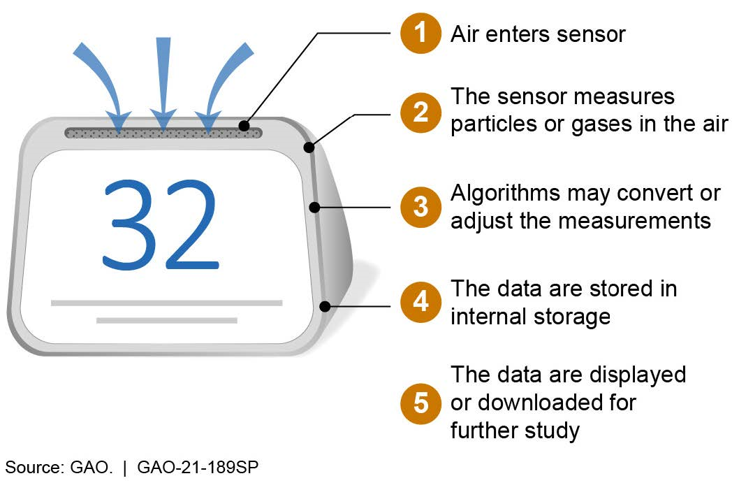
Figure 2. A low-cost sensor pulls air in to measure pollutants and stores information for further study.
How mature is it? Sensors originally developed for specific applications, such as monitoring air inside a building, are now smaller and more affordable. As a result, they can now be used in many ways to close gaps in monitoring and research. For example, local governments can use them to monitor multiple sources of air pollution affecting a community, and scientists can use wearable sensors to study the exposure of research volunteers.
However, low-cost sensors have limitations. They operate with fewer quality assurance measures than government-operated sensors and vary in the quality of data they produce. It is not yet clear how newer sensors should be deployed to provide the most benefit or how the data should be interpreted. Some low-cost sensors carry out calculations using artificial intelligence algorithms that the designers cannot always explain, making it difficult to interpret varying sensor performance. Further, they typically measure common pollutants, such as ozone and particulate matter. There are hundreds of air toxics for which additional monitoring using sensors could be beneficial. However, there may be technical or other challenges that make it impractical to do so.
Older satellite-based sensors typically provided infrequent and less detailed data. But newer sensors offer better data for monitoring air quality, which could help with monitoring rural areas and pollution transport, among other benefits. However, satellite-based sensor data can be difficult to interpret, especially for pollution at ground level. In addition, deployed satellite-based sensor technologies currently only measure a few pollutants, including particulate matter, ozone, sulfur dioxide, nitrogen dioxide, formaldehyde, and carbon monoxide.
Opportunities
- Improved research on health effects. The ability to track personal exposure and highly localized pollution could improve assessments of public health risks.
- Expanded monitoring. More dense and widespread monitoring could help identify pollution sources and hot spots, in both urban and rural areas.
- Enhanced air quality management. Combined measurements from stationary, mobile, and satellite-based sensors can help officials understand and mitigate major pollution issues, such as ground-level ozone and wildfire smoke.
- Community engagement. Lower cost sensors open up new possibilities for community engagement and citizen science, which is when the public conducts or participates in the scientific process, such as by making observations, collecting and sharing data, and conducting experiments.
Challenges
- Performance. Low-cost sensors have highly variable performance that is not well understood, and their algorithms may not be transparent. Low-cost sensors operated by different users or across different locations may have inconsistent measurements.
- Interpretation. Expertise may be needed to interpret sensor data. For example, sensors produce data in real time that may be difficult to interpret without health standards for short-term exposures.
- Data management. Expanded monitoring will create large amounts of data with inconsistent formatting, which will have to be stored and managed.
- Alignment with needs. Few of the current low-cost and satellite-based sensors measure air toxics. In addition, low-income communities, which studies show are disproportionally harmed by air pollution, may still face challenges deploying low-cost sensors.
Policy Context and Questions
- How can policymakers leverage new opportunities for widespread monitoring, such as citizen science, while also promoting appropriate use and interpretation of data?
- How can data from a variety of sensors be integrated to better understand air quality issues, such as environmental justice concerns, wildfires, and persistent ozone problems?
- How can research and development efforts be aligned to produce sensors to monitor key pollutants that are not widely monitored, such as certain air toxics?
For more information, contact Karen Howard at (202) 512-6888 or HowardK@gao.gov.