How Gaps in Weather Satellite Data Could Affect You
Heck of a lot of weather we’re having lately, with the polar vortex and record cold temperatures across the country. People rely on the weather forecast to determine how to be safe outdoors. This can also be important during hurricane season, as it was in October 2012 with Hurricane Sandy. As the hurricane was forming over the Atlantic Ocean, weather scientists were able to track the unusually large storm as it approached the U.S. Eastern seaboard and predict its path. Government authorities used this information to disseminate warnings and evacuation notices that likely saved countless lives. However, we have found that potential gaps in the availability of weather satellite data jeopardize the nation’s ability to accurately predict future weather events.
You can watch the video below to see why GAO added the potential gap in weather satellite data on the High Risk List in 2013.
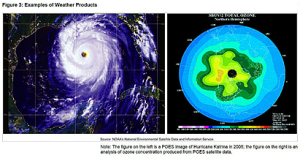 Weather satellites provide much of the data used to create weather prediction models, including forecasting the path and intensity of hurricanes. Federal agencies are currently planning and executing major satellite acquisition programs to replace existing satellite systems that are nearing the end of their expected life spans. However, these programs have troubled legacies of cost increases, missed milestones, technical problems, and management challenges that have resulted in reduced functionality and slips to planned launch dates. As a result, the continuity of satellite data is at risk.
Figure: Timeline for a Potential Gap in Polar Satellite Data in the Afternoon Orbit
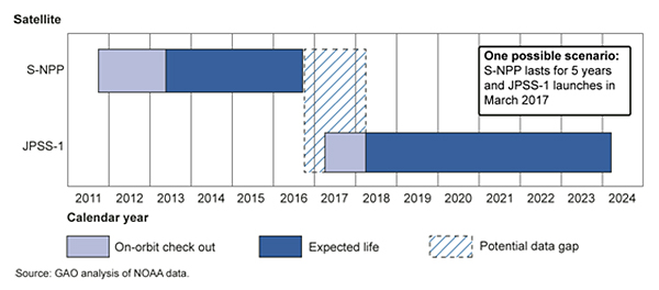
Image excerpted from GAO-13-676
- Questions on the content of this post? Contact David A. Powner at pownerd@gao.gov.
- Comments on GAO’s WatchBlog? Contact blog@gao.gov.